DIRT PRO, LLC Services

3D Data Preparation for GPS Machine Control
Many Contractors use Machine Control Systems on every project. These systems vary from 3D-GPS Systems to Total Station Systems. Following are the benefits of using DIRT PRO, LLC to handle your 3D Data Preparation regardless of type or brand.
- Turnkey Solutions for Every Project
- Research for Potential Design Errors and Seek Resolution with the Civil Engineers
- Constant Communication with All Members of Your Project Team to Ensure Applications and Details
- True Field Experience with Parameters of GPS Machine Control and Heavy Equipment
- Competitive Pricing and Quick Turnaround Times to Keep Your Equipment Running
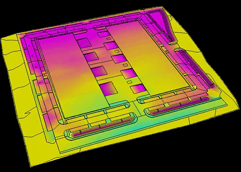
DIRT PRO, LLC delivers dependable 3D Site Models on time, every time. For all 3D Site Models we require Plans, Electronic Files (in AutoCAD or Microstation format), and Survey Control Information. Our 3D Site Models are customized to your exact specifications and we incorporate numerous details including: pad setbacks and overbuilds, flat bench offsets, stepped pad versus raked pad tolerances, retaining wall laybacks, etc. DIRT PRO, LLC combines experience and technology to generate the most accurate 3D Site Models to complement your Machine Control System.
A Finished Grade 3D Site Model (other scenarios available upon request) in a variety of file formats including:
- Topcon Files: TP3, LN3, TN3, PT3, and RD3
- Trimble Files: PRO, TTM, SVL, and SVD
- AutoCAD Files: DXF and DWG
- Other file formats available upon request
Incorporation of specified additional layers including: utilities, centerlines for roadway stations, limits of grading, etc.
Detailed Site Summary listing potential design discrepancies and additional information.

Earthwork Take-Offs
Accurate Earthwork Take-Offs are a crucial exercise within the Pre-Construction Process. DIRT PRO, LLC assists Contractors, Civil Engineers, and Developers by preparing detailed and easy-to-understand Reports and Supplemental Information.
For all Earthwork Take-Offs we require PDF Plans and Electronic Files (in AutoCAD or Microstation format) if available. We combine our experience with your specifications to deliver accurate information on time, every time. We offer the quickest turnaround time in the industry to meet your crucial deadlines.
- Overall Cut and Fill Volumes in raw cubic yards
- Detailed Reports featuring Areas (SF) and Volumes (CY) of specified Report Regions (ex: pad areas, streets, retention basins, parcels, units, etc.)
- PDF Cut & Fill Map (24” x 36” or 36” x 36”) of the entire project plotted to scale will be provided
- Detailed Site Summary listing potential design discrepancies and additional information
Newsletter Signup